NYC under flood and severe t-storm watches, travel advisory, with heavy rain forecast
July 31, 2025, 8:22 a.m.
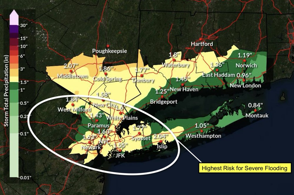
Three or more inches of rain could fall in parts of the region Thursday into Friday, meteorologists say.
New York City officials are warning residents to stay off the roads and prepare for flash flooding as hefty storms are forecast to roll through the area Thursday afternoon into Friday.
According to the National Weather Service, the city can expect anywhere from 1.5 to 3 inches of rain due to a frontal system stalling above the region and bringing repeated rounds of showers and thunderstorms. Other areas could see as much as 5 inches of rain by Friday, meteorologists said.
The NWS issued a flood watch for the metro area from 2 p.m. Thursday to 8 a.m. Friday, and a severe thunderstorm watch until 8 p.m. Thursday. City officials issued a travel advisory, urging people to stay home if possible and reminding those who live in low-lying areas to stay vigilant for any flooding.
“We have activated the Flash Flood Emergency Plan and are coordinating closely with the National Weather Service and partner agencies,” Emergency Management Commissioner Zach Iscol said in a statement. “Make a plan now, stay alert to changing conditions, and be ready to move quickly at the first sign of rising water, especially if you live in a basement or other below-grade space.”
Officials also asked residents to help prevent street flooding by clearing debris from local catch basins. New Yorkers can report clogged basins online or by calling 311.
A flood WATCH remains in effect for the entire area. Rainfall begins later this morning and continues into this evening. Have a reliable source of weather information and be prepared to take action if flash flood WARNINGS are issued. Latest forecast at https://t.co/wTqdsomHTB pic.twitter.com/ZnKYOiOZPy
— NWS New York NY (@NWSNewYorkNY) July 31, 2025
New York Gov. Kathy Hochul said state agencies are also preparing for heavy rain and possible flooding. Her office encouraged residents to sign up for real-time weather and emergency alerts by texting their county or borough name to 333111.
Heavy rain earlier this month caused widespread travel disruptions across the region and flooded transit systems, including subways and commuter rails. Two people died in Plainfield, New Jersey, when flood waters swept their car into a nearby brook.
NWS meteorologist Dave Radell said early Thursday it was still hard to predict which communities could be hit the hardest by the predicted storms. He advised people living near creeks or rivers or in urban areas with poor drainage to be on the lookout.
“Once we get past this this afternoon and this evening, the next couple of days will be cooler and drier as we get into the weekend and early next week,” he said.
New Yorkers can expect sunny skies, lower humidity and temperatures in the high 70s and low 80s Saturday and Sunday, according to the National Weather Service.
Visit the NYC Emergency Management website for more storm preparedness information.
This story has been updated with additional information.
3 days of blistering heat are headed to NYC area, with real-feel temps up to 104