NYC subway geyser caused by ancient Manhattan stream
July 18, 2025, 12:06 p.m.
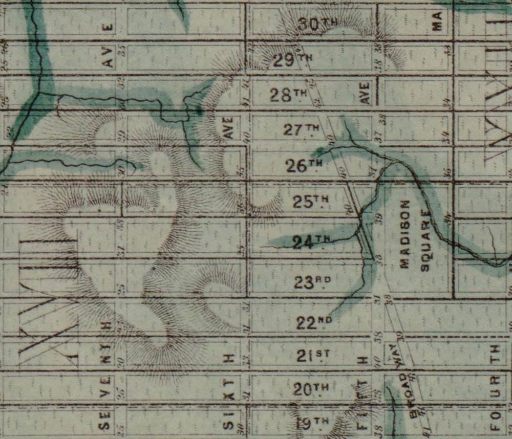
The 28th Street station on the 1 line is uniquely vulnerable to flooding.
This column originally appeared in On The Way, a weekly newsletter covering everything you need to know about NYC-area transportation.
Sign up to get the full version, which includes answers to reader questions, trivia, service changes and more, in your inbox every Thursday.
Manhattan’s precolonial topography is to blame for the 28th Street Station subway geyser that bursts with bubbling water during heavy rain.
The manhole cover on the subway platform flooded in spectacular fashion, yet again, during Monday’s storm. MTA Chair Janno Lieber blamed the phenomenon on the city’s aging sewer system, which proved incapable of handling the more than 2 inches of rain that fell in a single hour that night.
But the same sewers also handled rainwater at every other station across the city, where flooding seldom reaches the same levels. That’s because Manhattan’s primordial terrain makes the 28th Street station uniquely vulnerable.
A topographical map of New York City from 1865 shows that the station at 28th Street and Seventh Avenue was built on marshland, with water flowing in from multiple blocks.
“Before there was 28th Street there was a forest and in that forest there was a wetland, and it turns out that the 1 train stop at 28th Street is right smack in the middle of that wetland,” said Eric Sanderson, the vice president for Urban Conservation Center for Conservation and Restoration Ecology at the New York Botanic Garden.
Sanderson said paving over that wetland only made flooding worse. Where water was once absorbed by dirt and trees, there’s now very little stopping it from flowing underground — and into our subway system.
“ It turns out that even though we have built all these big buildings and built roads everywhere, that topography is still there, and water, just as it always has done, runs downhill,” he said.
In the late 19th and early 20th centuries, Sanderson said, the city installed sewer pipes large enough to handle typical rain storms during that period. But climate change means that storms are growing stronger and more frequent.
“ They were adapted for the climate at the time,” he said. “You'd have to tear them out, put them in larger [ones], guess what the climate of the future is going to be and hope it's big enough.”
He estimates 20% of New York City is in a “blue zone,” where water used to gather. Those areas are now prone to flooding.
“ I think that fundamentally goes to sort of an equity question: Are you going to let other parts of the city flood and then protect this part of the city?” Sanderson said.
For his money, there’s only one sure bet. “ In the long run, I don't think you can deny nature.”
NYC transportation news this week
A three-block bike lane is now a central issue in Mayor Eric Adams' re-election campaign. In June he ordered the transportation department to move the newly installed protected bike lane on Bedford Avenue away from the curb. The mayor’s critics chastised it as a political move aimed at garnering political support from Hasidic Jewish voters.
Big changes are in store for East Harlem. The MTA is ramping up work on the long-awaited extension of the Second Avenue subway.
Can you guess which U.S. counties rank highest for "active transportation?" Unsurprisingly, you probably know several of them by their borough names.
The city is proposing new ferry routes, including a direct service from the Bronx to the Rockaways.
Tune in at 4:50 p.m. today to hear us talk about all things transit. To get the full benefits of this newsletter, you simply must listen to the audio component. (Listen live via the new WNYC app!) Also, here's last week's segment. (You can also watch a condensed version on social media if that's more your vibe).
Have a question for us? Use this form to submit yours and we may answer it in a future newsletter!
Curious Commuter questions are exclusive for On The Way newsletter subscribers. Sign up for free here.
Question from Michael in Queens
With the rollout of the first part of the new Queens bus routes and schedules, I see a lot of buses that say "Rush." What does this mean?
Answer
The MTA is implementing a complete redesign of the Queens Bus Network, which includes adding new “rush” routes. The purpose of the new routes is to better serve commuters who live farther away in residential neighborhoods. Rush routes make more frequent stops in residential areas and fewer stops in busier downtown areas like Flushing and Jamaica. They get more people in transit deserts to the subways, and aim to do it faster. A map of the new bus networks shows most rush routes are located in Eastern and Southeastern Queens, in neighborhoods like Floral Park, Glen Oaks, Queens Village and Rosedale. The full redesign project was split into two phases. The first phase started in June, while the second will be completed on Aug. 31.
It's NYC's own 'Old Faithful.' Chelsea subway station spews again during downpour.