New Mapping Of Titanic Wreckage Shows Site Like Never Before
March 9, 2012, 5:45 p.m.
The Titanic site has been painstakingly mapped, giving a new view of the tragic wreck.
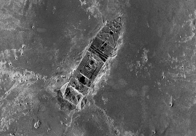
A portion of a comprehensive map of the debris field surrounding the bow and stern of the Titanic, via The AP
Almost 100 years after the tragedy, researchers have assembled a massive North Atlantic debris field map of the Titanic's wreckage, something that's never been done before. According to the Daily News, they took 130,000 photos using underwater robots and solar imaging, which together created the most in-depth look we've ever had of the 3 x 5-mile underwater debris field. A senior VP at the History Channel, who spearheaded the project, says, “We’ve got this vision of the entire wreck that no one has ever seen before. Because we have, we’re going to be able to reconstruct exactly how the wreck happened. It’s ground-breaking, jaw-dropping stuff.” Take that, James Cameron.
With the sonar maps, it's easier for Titanic researchers to see the entire site, without missing parts—or as one historian put it, "it's like suddenly the entire room lit up and you can go from room to room with a magnifying glass and document it. Nothing like this has ever been done for the Titanic site."
So why do we need to keep delving into the shipwreck? According to the Wall Street Journal, "By examining the debris, investigators can now answer questions like how the ship broke apart, how it went down and whether there was a fatal flaw in the design. The layout of the wreck site and where the pieces landed provide new clues on exactly what happened."
The History Channel will air their findings in a two-hour documentary on April 15th, exactly 100 years after the Titanic sank. But as we now know, we've got the supermoon to blame.